
Sawtooth & Western Smoky Mtns
Backcountry Avalanche Forecast
Sawtooth Avalanche Center
www.sawtoothavalanche.com
Author: Everett Coba
Issued: Saturday, April 4, 2026 at 6:20 AM MDT
Expires: Sunday, April 5, 2026 at 4:00 AM MDT
The Bottom Line
 The Bottom Line
Today's warm sun will cause loose avalanches and may rapidly consolidate storm snow into a triggerable slab. Watch for and avoid fresh wind drifts and slabs. Expect them to be larger and more common as you climb in elevation. You can reduce your risk by seeking out slopes that face away from the sun, where the snow surface remains soft and dry.
We will issue our last daily Avalanche Forecast of the season this Sunday, April 5th. We will issue General Avalanche Information updates through late April or early May.
Avalanche Danger
Saturday, April 4, 2026
(⇡9000') 2 - Moderate

(7500-9000')2 - Moderate
(⇣7500')1 - Low

Sunday, April 5, 2026
(⇡9000') 2 - Moderate
(7500-9000')2 - Moderate
(⇣7500')1 - Low
Avalanche Danger ScaleLearn moreGeneral InfoGeneral Information1 - LowLow2 - ModModerate3 - ConsConsiderable4 - HighHigh5 - ExtrExtreme
1 - Low | 2 - Moderate |  3 - Considerable |  4 - High |  5 - Extreme | |
|---|---|---|---|---|---|
| Travel Advice | Generally safe avalanche conditions. Watch for unstable snow on isolated terrain features. | Heightened avalanche conditions on specific terrain features. Evaluate snow and terrain carefully; identify features of concern. | Dangerous avalanche conditions. Careful snowpack evaluation, cautious route-finding and conservative decision-making essential. | Very dangerous avalanche conditions. Travel in avalanche terrain not recommended. | Extraordinarily dangerous avalanche conditions. Avoid all avalanche terrain. |
| Likelihood of Avalanches | Natural and human-triggered avalanches unlikely. | Natural avalanches unlikely; human-triggered avalanches possible. | Natural avalanches possible; human-triggered avalanches likely. | Natural avalanches likely; human-triggered avalanches very likely. | Natural and human-triggered avalanches certain. |
| Avalanche Size and Distribution | Small avalanches in isolated areas or extreme terrain. | Small avalanches in specific areas; or large avalanches in isolated areas. | Small avalanches in many areas; or large avalanches in specific areas; or very large avalanches in isolated areas. | Large avalanches in many areas; or very large avalanches in specific areas. | Very large avalanches in many areas. |
Avalanche Problems (2)
Problem #1: Wet Loose
Problem Type
Wet Loose
Aspect/Elevation
Likelihood
Size
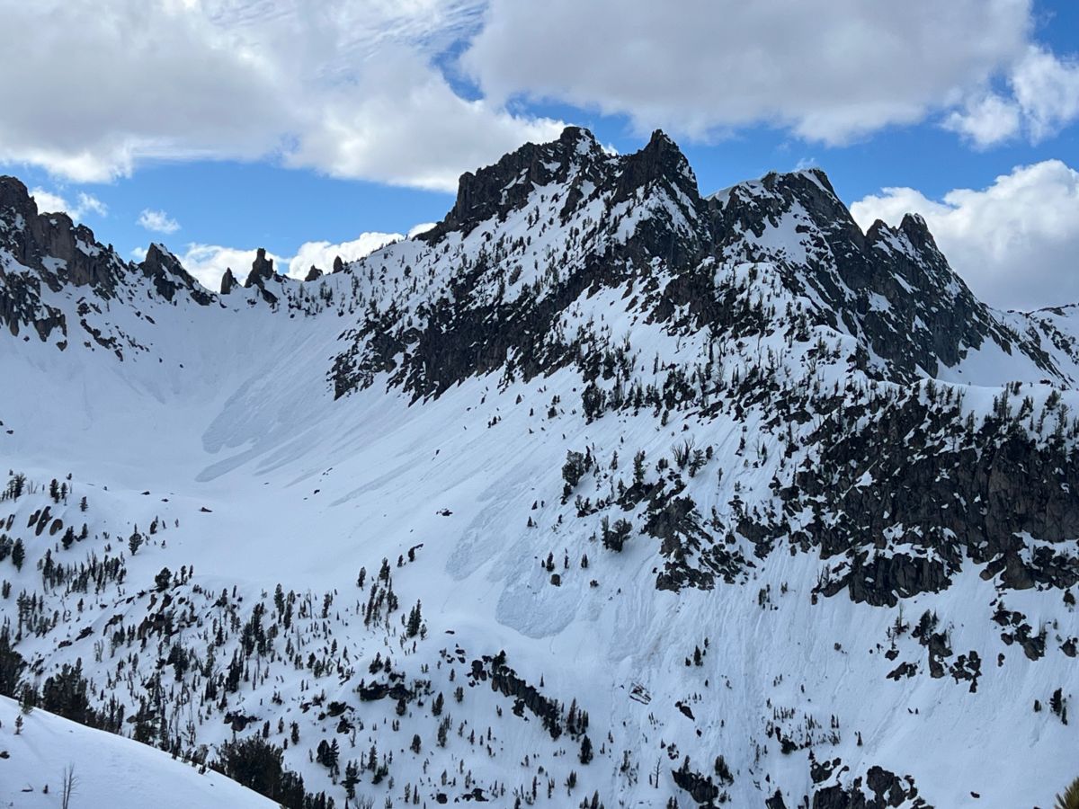
(3/22/2026) Wet loose avalanches in the central Sawtooths.
Clear skies and warm sun will cause natural wet loose avalanches. Expect avalanche activity to begin on E and SE facing slopes and follow the sun through the southern sky, ending on W and NW facing slopes this afternoon. Although many of these will start small, they have the potential to become large and destructive if they gouge into a wet snowpack.
Wet loose avalanches often initiate near the base of trees, rocks, and cliffs. Although slow-moving, these avalanches are surprisingly powerful and difficult to escape. Large relief or channeled terrain can increase the size and consequence of being caught. Roller balls or small sluffs are clues that the snow surface is heating up, and wet loose slides may follow.
Problem #2: Wind Slab
Problem Type
Wind Slab
Aspect/Elevation
Likelihood
Size
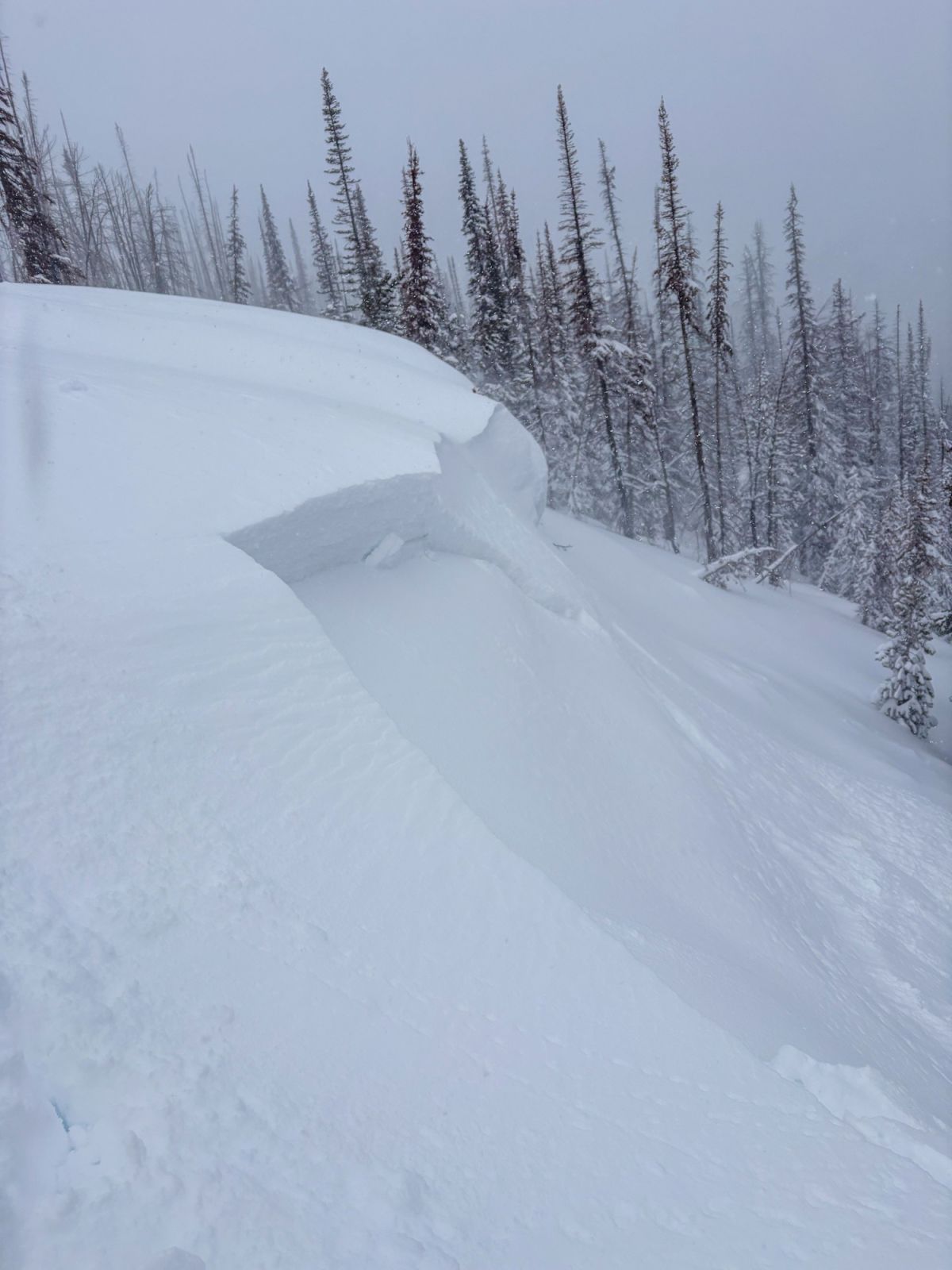
(4/2/2026) Small soft slabs and cornice were triggerable along this wind-loaded ridge line in the mountains near Smiley Ck.
Photo: Sawtooth Avalanche Center
The most recent storm, which ended on Thursday, formed drifts and slabs at upper elevations. Although now a few days old, some sensitive slabs could still be lingering on steep, exposed upper-elevation slopes.
Yesterday, we observed multiple large natural slab avalanches failing in shaded alpine terrain in the Sawtooths. These avalanches likely failed during or just after the most recent storm. Triggering similar avalanches today remains possible.
Look for this problem near and just below exposed ridgelines, large cliffs, and along cross-loaded mid-slope gullies. Recent cornice growth, pillows, and dunes are all clues that wind was at work moving snow. Cracking in the snow surface is a sure indication that you've found a sensitive slab. You can reduce your odds of triggering a wind slab by sticking to more wind-sheltered slopes with soft powder at the surface.
Additional Discussion - Storm Slabs: Today's warm sun will rapidly consolidate recent dry powder into a heavier and potentially sensitive slab. Overcast skies yesterday morning likely did little to consolidate snow surfaces on E-NE facing slopes. Today will be the first day that the new snow on these aspects will see direct sunlight. Watch for cracking/ collapsing on slopes that are still holding dry powder and are now being exposed to the sun.
Forecast Discussion
Today, seeking the softest, driest snow is also the best way to reduce your odds of triggering a large avalanche. Slopes most likely holding soft dry snow are NW-N-NE at the middle/upper elevation transition.
Expect conditions to change rapidly as the sun and warm air temperature cook snow surfaces. The sun is extremely strong this time of year; it won't take long to turn dry powder into mashed potatoes.
Consider an early start and exit to maximize enjoyment and to minimize risk.
Mountain Weather
Author: Everett Coba
Issued: Saturday, April 4, 2026 at 5:11 AM MDT
Yesterday started cloudy, and gradually cleared through the day. Temperatures climbed into the 30s F. NW winds were light.
Last night, the skies were clear, and the wind was generally light from the NW. Temperatures cooled into the high teens to 20s F.
Today will bring clear skies, with light winds with variable directions. Temperatures will climb into the 30s to low 40s F.
Tonight, clear skies persist. Temperatures should cool into the 20s F. Winds stay light, with the direction shifting to the south.
Tomorrow is expected to start clear, with gradually building clouds by the afternoon. Winds should generally be light. Temperatures are expected to be 5 to 10 degrees warmer than today, reaching the mid-40s F in most areas.
| Sawtooth & Western Smoky Mtns | Last Night (5PM - 5AM) | Today (5AM - 5PM) | Tonight (5PM - 5AM) | |
|---|---|---|---|---|
| Temperature | 20 to 25 F | 35 to 40 F | 23 to 28 F | |
| Cloud Cover | Clear | Clear | Clear | |
| Ridgeline Wind Speedⓘ | Light | Light | Light | |
| Wind Direction | NW | NW | S | |
| Snowfallⓘ | 12hr: 0 " | 24hr: 0 " | 0 " | 0 " |
| Snow Water Equivalentⓘ | 12hr: 0 " | 24hr: 0 " | 0 " | 0 " |
This information is provided by the U.S.D.A. Forest Service and describes general backcountry avalanche hazard and conditions.
It does not apply to ski areas and highways where avalanche mitigation is conducted.